


Help from on high
A technology that has been around for decades is emerging as a powerful “new” tool in solving agriculture’s most urgent problems. The difference between then and now is in the clarity and frequency of satellite imagery, and agriculture’s vastly improved ability to leverage it.
Satellite advancements have made it possible for growers and ranchers to keep an eye on their fields remotely and in near real time to detect problems before they get out of hand. At resolutions of 1-5 meters and better, these images can provide very detailed information on animal inventory, grazing capacity, and even predict cattle weight gain on rangelands.
For growers, satellite imagery is being used to monitor crops in near real-time throughout the season, to assess soil properties, prevent disease, pests and crop loss, and determine when inputs are needed to optimize yields.
“Satellite imagery is exploding into many new use cases for farmers and agribusiness,” notes Stephanie Giard, Senior Product Marketing Manager, Agriculture, at Planet.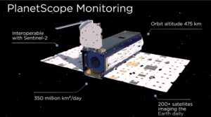
“Field operation optimization, irrigation management, crop ID for yield prediction, even harvest dynamics and pasture management. You can pull very tiny slices of information that can give you a more detailed view of something very specific, like soil composition.”
Satellite imagery has become a competitive differentiator
The number of satellites is expanding the quantity and quality of data available to growers and agribusiness. Planet alone has more than 200 satellites in orbit that collect over 350 million square kilometers of imagery. Analysts say it is a market poised for enormous growth and competition, fueled by the urgent need to produce more food and reduce carbon emissions, as well as improvements in satellite technology.
Remote sensing has moved beyond optical imagery to all weather-technology called SAR (Synthetic Aperture Radar), which uses microwaves to capture images at night and through clouds. SAR improves the ability to detect change over time in a way that is more consistent for accurate comparisons. Indigo Ag is using SAR to create a spatial analysis that helps farmers with production insights, like whether to use more or less irrigation, or whether a product works better in silty loam or clay loam soil.
Syngenta and Corteva have made satellite imagery a key component of their digital farming platforms to help farmers track field performance, crop health, and problem areas that can’t be efficiently seen from the ground. Arva Intelligence, an AI analytics company, is using remote sensing and agronomy data to capture and quantify the environmental value of acres to help grow the market for carbon credits. Manna Irrigation has built its whole business around remote sensing, developing a sensor-free, satellite-based intelligence software to optimize irrigation planning and scheduling.
Everything old is new again
The visual acuity of satellite imagery today is like looking at an old movie that’s been digitally remastered, giving clarity and definition to what had been cutting edge technology at the time. Just like the image resolution of TV monitors and phone screens have advanced, spatial resolution is possible at square centimeters, and in areas where on-the-ground measurements previously were not possible.
While remote sensing has value on its own, the real power is in layering geospatial data with field and market data. That’s when patterns and insights emerge to be turned into actionable intelligence.
Libba Stanford is a strategic spatial intelligence advisor.
“Remote-sensing has revolutionized our ability to partner with the Earth in a more sustainable way,” she notes. “Tremendous advancements in logistics, processing, and analysis are allowing us to leverage these capabilities, especially when combined with other data from below and above the soil. It’s a really exciting time to be in the geo technology space for agriculture.”
Satellites’ biggest barrier to entry
The cost of satellite imagery has been a lot to swallow for farm advisors and agribusinesses. It appears that is changing, as they compare the cost of scouting, crop loss, and inputs against the competitive and sales advantage of value-added features and higher yields.

Imagery courtesy of Planet . Idaho NDVI satellite image.
Satellite imagery data is rarely used on its own, but as a part of large data sets for specific uses. Skyward helps simplify the technical complexity of assimilating a staggering amount of data from satellites that must be processed before it can be used.
The data is not downloaded like snapshots from a camera. It’s raw data, binary information, and requires processing, decoding, calibrating and transforming it into usable data takes advanced agtech expertise.
“Technology comes with complexity,” notes Skyward Apps’ CTO Nick Elliott. “You wouldn’t expect a truck driver to be able to sit down and pilot a jetliner. Not all skills are transferable.”
“It’s not a minor lift,” adds Planet’s Giard. “There is a lot of work involved. The potential for the number of people in the next five to 10 years that will be using remotely sensed is incredibly large, and I bet that probably one or two percent have the technological expertise to take it from the raw data all the way through to the answers. We need companies like Skyward who can do the heavy lifting to help people get this implemented and built properly into their infrastructure.
Why is the market skyrocketing (so to speak)?
As Croplife editor Eric Sfiligo noted in a recent article, the initials “a.i.” used to refer to “active ingredients” Now, four pages into a Google search, the only topic is artificial intelligence.
Data is the raw material of machine learning and AI, and data from satellites, sensors and other sources are creating predictive models that will be game changers for the business. Models trained on vast data, will enable farmers to predict crop maturity dates, crop performance and mitigate risk. In fact, AI models will be able to determine the potential yield rates of a crop before the vegetation cycle even begins and extract information to predict crop prices before farmers can even report their yields.
“AI will redefine precision agriculture,” said Skyward’s Elliott. “We have built and unified custom software for decades to take complex scientific data and distill it down to concrete, actionable suggestions. AI creates a new benchmark on which to build decision tools and models that will accelerate solutions for food security and climate change.”
If you’ve been thinking of adding satellite mapping and data intelligence to make better strategic decisions, let us explain what’s involved. There are no costs for a consultation.