


Big Picture, Hidden Risks
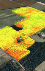
Who isn’t awed by the vivid clarity of drone imagery? With ultra-high resolution, multispectral imagery, you can spot an aphid on a soybean leaf well before those pests are well established. What drone imagery can’t do is provide a complete spatial image; it must be pieced together. Drones and satellites don’t compete as much as they complement each other. When a satellite image shows a problem area, a drone will tell you what the problem is. Together they present a holistic view of what’s happening on a farm.
But what happens when those images don’t match up? More important, what happens when you don’t know to check if the images match up? Tiny discrepancies in raw data can skew the end result of all of your analysis, agronomic and financial models. From yield monitors to soil samples to weather apps and satellite imagery, farmers know more about the condition of their crops today than ever before. But each new source of data brings new technical challenges that can alter the data before you can analyze it.
What makes each data source different
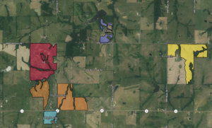
Satellite imagery to assist in planting
In adding new data sources, whether from satellites, drones or aerial photography, you need to understand what makes each data source different and how to combine them to ensure the data you’re analyzing is valid. Here are three examples of tiny discrepancies that can alter raw data used to inform decisions.
Make sure your comparisons are accurate
Data drift. Let’s say you have two image sources, such as data from two satellites or from a satellite and a drone . When the resolution of one image is set at 30 meters and you compare it to an image resolution at 20 meters, you have what software engineers call “data drift. If there is a meaningful drift in underlying data, models built on that data will be off.
Make sure your coordinates are consistent
What if one source of remote sensing data is using the North American GPS model while another uses the Global Ellipsoid Model to enter latitude and longitude? Often these systems are interchangeable, but with high-resolution imagery, the difference of just one foot can mean your entire data set is off by one or two feet. The impact could be thousands of dollars when applied to precision and variable rate applications.
 Make sure your calibration is correct
 Make sure your calibration is correct
Another common mistake we see is taking imagery data as truth. While most of the time an image is accurate, there are occasions where there’s cloud coverage you’re unaware of, the calibration was incorrect, or even a faulty sensor that throws the data off. If you don’t know how to recognize these inaccuracies, you’re likely making poor interpretations of the data, and these errors and oversights ultimately result in poor decision-making, for you and your customers.
There is no room for errors in integrating agriculture data. It’s importance to crop yields, commodity markets, the food supply and the agricultural ecosystem all depend on the validity of data to form a single source of truth.
Having Data is not the same as Using Data
One of the most powerful benefits of technology is the ability to pull and unify these massive data sets to help farmers visualize their fields to see where action is needed to prevent crop loss. As complementary tools, satellite and drone data are making new information possible. 
However, there’s so much data already collected and ingested that its full potential may not even be realized – or needed by many farmers. If, for example, your growers are using satellite imagery to assess their tile drainage needs, they probably don’t need the same resolution or immediacy of data as farmers monitoring fields for pests and disease.
It’s easy to get swept up in believing we all need cutting-edge technology to keep up with competitors and take our business to the next level, but sometimes it’s better to re-examine available resources and look for new opportunities to extract more value. Good agribusinesses—and good software partners—do that.
Before you invest in new methods of remote sensing, integration of software applications, or outsource development and integration to a vendor not steeped in precision ag, get a second opinion. We can assess or audit your existing data capabilities as they relate to your business goals.
There’s a clear correlation between the way you manage data and the value of your business. Let us walk you through the process and explain what to expect.
Ask our experts.